

Bahía Blanca relocation guide
Bahía Blanca Safety
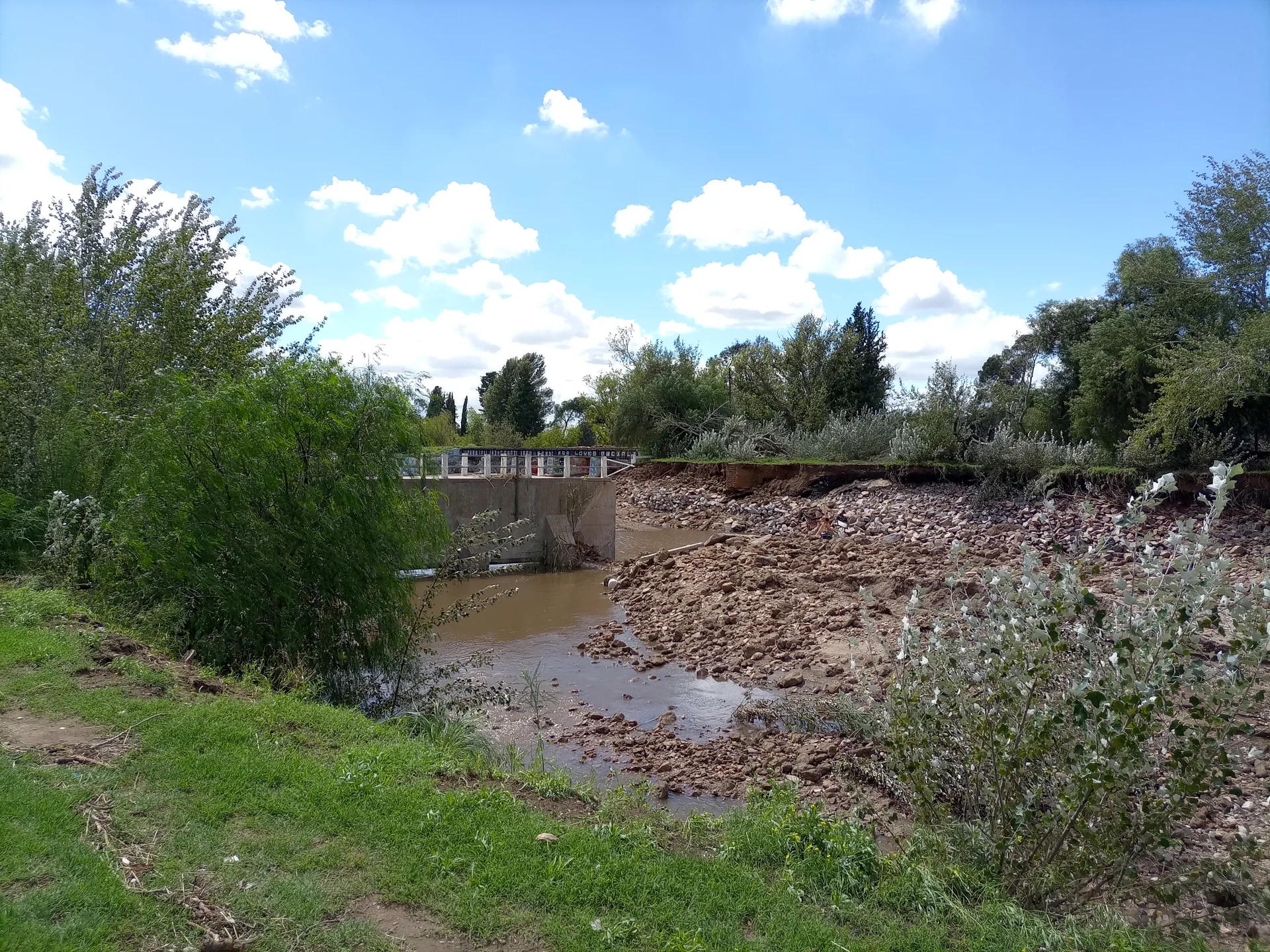
The strongest local risk evidence concerns the 2025 flood and subsequent recovery. An exact property needs its own inspection.
- Documented flood
- March 7, 2025
- Municipal emergency declaration
- Covered-channel inspection
- August 28, 2026
- A specific 4 km section, not a parcel guarantee
- Road report
- September 14, 2026
- Dated recovery work, check present condition
- Neighborhood crime
- Unranked
- No matched denominator verified
On this page
The short answer
The retained evidence cannot rank Bahía Blanca neighborhoods by crime risk. Municipal Decree 394 records the March 7, 2025 flood and the district emergency. Later reports document channel inspection and road repairs, but cannot guarantee any rental avoids future flooding. Check the exact parcel, floor, damage and insurance terms, alongside your daily walking and transport routes.
- Documented flood. March 7, 2025. Municipal emergency declaration.
- Covered-channel inspection. August 28, 2026. A specific 4 km section, not a parcel guarantee.
- Decision. Treat a property-specific flood and access check as part of the housing decision. Leave crime comparisons unranked until geography and denominators match.
- Next step. Ask the operator about damage, drainage and repair history during the viewing.
What the evidence supports
The documented event and later work
Municipal Decree 394 of March 8, 2025 records the March 7 flood and declares a broad emergency for the Bahía Blanca district. A historical emergency and substantial damage are verified. It does not prove every listed neighborhood flooded equally or every property remains damaged. Current recovery and exact parcel exposure need separate checks.1
The municipality reports inspecting four kilometers of the covered Napostá channel on August 28, 2026, from Paseo de las Esculturas to the bus-terminal area. The report says this closed section was clear and operating when inspected. It is not a no-flood guarantee or a parcel-specific exposure assessment.2
The municipal September 14 road-recovery notice reports 74 completed and 18 active intersection works. A dated municipal progress report. It does not prove all streets or flood damage were restored by October. Inspect the exact access route.3
Keep geography and probabilities separate
The retained municipal KML names and draws Centro Norte, Centro Oeste, Universitario, Palihue, Villa Mitre and Bella Vista. The official KML filename dates to January 9, 2020. It supplies historical area geometry, not current boundary recertification, a rental entrance or physical-access proof.4
SMN and WMO 1991 to 2020 normals for Bahía Blanca Aero give annual mean temperature of 15.4°C (59.7°F) and annual precipitation of 639.1 mm. The airport station is approximately 8.9 km straight-line from the Georef locality centroid. Rain days use at least 1 mm. Normals do not predict the next storm or parcel flood probability.5
Know the purpose of each number
Bahía Blanca publishes 911 for incidents and crime, 107 for medical emergencies and 109 for municipal response, with Defensa Civil at Santa Fe 340. Use the purpose listed by the municipal source. No emergency response time is claimed.6
Make the connected decisions
- Bahía Blanca Rent. Ask the operator about damage, drainage and repair history during the viewing.
- Bahía Blanca Weather. Separate a seasonal rain pattern from the rental's flood exposure.
- Bahía Blanca Accessibility. Test the exact curb, entrance and lift along the intended route.
- Getting Around Bahía Blanca. Check present outward and return operation after street repairs.
- Bahía Blanca Neighborhoods. Use boundaries to locate a shortlist without inventing a crime ranking.
- Moving to Bahía Blanca. Put parcel inspection before the financial commitment in the arrival sequence.
- LGBTQ Life in Bahía Blanca. Use the documented identity protections and local contacts without treating them as a measured neighborhood safety score.
Questions people ask
Is Bahía Blanca safe for a move?
Treat a property-specific flood and access check as part of the housing decision. Leave crime comparisons unranked until geography and denominators match.
Does the Napostá inspection remove flood risk?
No. The August report describes the condition of a specific four-kilometer covered section. It does not assess every parcel or promise future protection.
Can the 2022 census denominator produce a 2025 crime rate?
Not as a published current rate. A count, reporting geography and population period must match. The guide does not invent that denominator.
What did Decree 394 record after the Bahía Blanca flood?
Municipal Decree 394 of March 8, 2025 records the March 7 flood and declares a broad emergency for the Bahía Blanca district. A historical emergency and substantial damage are verified. It does not prove every listed neighborhood flooded equally or every property remains damaged. Current recovery and exact parcel exposure need separate checks.
Which covered Napostá section was inspected in August?
The municipality reports inspecting four kilometers of the covered Napostá channel on August 28, 2026, from Paseo de las Esculturas to the bus-terminal area. The report says this closed section was clear and operating when inspected. It is not a no-flood guarantee or a parcel-specific exposure assessment.
What did the September road-repair announcement establish?
The municipal September 14 road-recovery notice reports 74 completed and 18 active intersection works. A dated municipal progress report. It does not prove all streets or flood damage were restored by October. Inspect the exact access route.
How do I contact municipal Civil Defense for local information?
Bahía Blanca publishes 911 for incidents and crime, 107 for medical emergencies and 109 for municipal response, with Defensa Civil at Santa Fe 340. Use the purpose listed by the municipal source. No emergency response time is claimed.
Do airport climate normals establish a rental's flood probability?
SMN and WMO 1991 to 2020 normals for Bahía Blanca Aero give annual mean temperature of 15.4°C (59.7°F) and annual precipitation of 639.1 mm. The airport station is approximately 8.9 km straight-line from the Georef locality centroid. Rain days use at least 1 mm. Normals do not predict the next storm or parcel flood probability.
Do historical neighborhood polygons establish current parcel safety?
The retained municipal KML names and draws Centro Norte, Centro Oeste, Universitario, Palihue, Villa Mitre and Bella Vista. The official KML filename dates to January 9, 2020. It supplies historical area geometry, not current boundary recertification, a rental entrance or physical-access proof.
Plan your move
Get a free relocation plan for Bahía Blanca.
Answer three questions and get your tasks in order, ready to print or save.
- Answer three questions
- Get your tasks in order
- Print it or save it
Our packages are available for moves to Santiago today. For other cities, we confirm providers, requirements, and fees before you pay.
Sources and how we check them
Sources and how we check them7 sources
Every figure on this page comes from the official or primary source listed here. We checked them in . Rules and prices change, so confirm anything important with the source before you act on it.
- Bahía Blanca municipal emergency declaration March 8 2025 (opens in a new tab)
- Bahía Blanca Napostá culvert inspection August 28 2026 (opens in a new tab)
- Bahía Blanca road intersection reconstruction September 14 2026 (opens in a new tab)
- Municipality, original official-neighborhood KML geometry (opens in a new tab)
- NOAA SMN Bahía Blanca Aero 1991 to 2020 normals station 87750 (opens in a new tab)
- Bahía Blanca municipal emergency and civil defense contact (opens in a new tab)
- BCRA USD reference quote, October 8, 2026 (opens in a new tab)
Bahía Blanca flood aftermath, photographed in 2025. Hero photo by Ni.cero, CC BY-SA 4.0 (opens in a new tab), from Wikimedia Commons (opens in a new tab).